.jpg)
-Tablet_mobile.jpg)
Photo Credit
Whether deep in the backcountry or on open water, proper navigation is a must. And for route finding, recording tracks, or finding a geocache, there’s no more durable and long-lasting navigator than a handheld GPS. While it will never fully replace a map and compass, outdoor GPS devices allow you to plan, follow, and record your adventures, even sharing them with friends back home. From the remote bush of Africa to lofty peaks in Nepal, we've been putting GPS devices through their paces in the backcountry since 2016, and our favorite is the Garmin GPSMAP 67i. For more information, see our detailed comparison table, buying advice, and breakdown of how we approach testing.
Editor's note: We updated this guide on January 22, 2026, to add the Garmin inReach Mini 3 Plus, Garmin Montana 710i, and Bushnell BackTrack Mini GPS, and add photos from recent testing trips. We also combed through the guide to ensure prices, colors, and products were current at the time of publication.
 Weight: 8.1 oz.
Screen: 3.0 in.
Battery life: 180 hours (840 in expedition mode)
Memory: 16 GB (accepts 32 GB microSD)
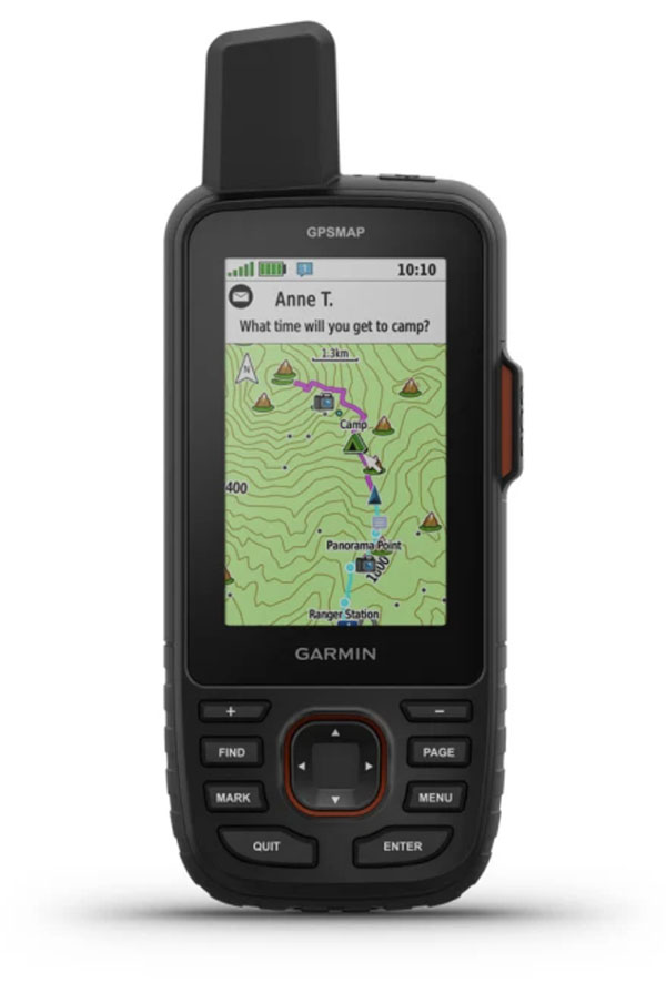
What we like: A premium GPS device with satellite messaging/SOS.
What we don’t: Expensive and no touchscreen capability.
The GPSMAP 67i is Garmin’s premier handheld GPS device, packing their top-of-the-line navigation tools into a rugged design, along with the added benefit of satellite messaging and SOS via inReach (Garmin acquired the company in 2016). Updated from the 66, it offers a significant improvement in battery life—up to 180 hours in GPS mode and 840 hours in power-saving expedition mode—as well as compatibility with Garmin’s Outdoor Maps+ subscription (previously available only with the Montana series). To top it off, the 67i’s hardware is best-in-class within the GPSMAP lineup, featuring a high-resolution 3-inch screen, 16 GB of memory, and Wi-Fi connectivity.
Like most Garmin GPSMAP offerings, the 67i features an external antenna, ABC sensors, multi-GNSS support, and the ability to connect to multiple GNSS frequencies simultaneously. In other words, it’s just about as good as it gets when it comes to location accuracy and tracking. We also really appreciated the added inReach support—for explorers headed into areas without cell service, the ability to send and receive messages, share a track, access weather forecasts, and initiate rescues is a game-changer (note: A subscription plan is required to use these features). It is worth noting that, while the 67i’s lithium-ion battery is long-lasting and rechargeable, some might appreciate the simple convenience of AAs offered by something like the GPSMAP 65 series. But all told, the GPSMAP 67i is one of the most impressive handheld GPS devices available.
See the Garmin GPSMAP 67i
 Weight: 5.5 oz.
Screen: 2.2 in.
Battery life: 168 hours (1,800 in expedition mode)
Memory: 28 MB
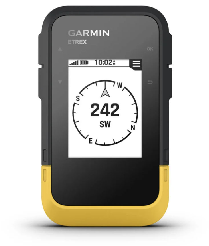
What we like: Incredible battery life and great feature set at a budget price.
What we don’t: Requires a smartphone connection to access many features.
Expensive GPS devices offer an overwhelming and, for some, unnecessary number of features. With that in mind, a good number of outdoor-goers will find plenty to like with Garmin’s budget-friendly eTrex SE. Importantly, the device is simple to use and offers great accuracy with multi-GNSS support (including GPS, GLONASS, Galileo, QZSS, and BeiDou); features a tough, water-resistant construction (IPX7); and boasts an impressive battery that lasts a full week in standard mode. Whether you’re searching for geocaches, looking for the most up-to-date weather forecast, or following a preloaded track, it’s an intriguing entry from Garmin and priced right at just $150.
The most important thing to know about the SE is that it requires a connection to the Garmin Explore app on a smartphone to access many of its features. Garmin’s eTrex 22x and eTrex 32x have more on-board storage and functionality (including preloaded maps)—and tack on a color screen—and the 32x also includes a compass and barometric altimeter. That said, neither can beat the SE’s improved position accuracy, especially in deep canyons or under heavy cover (the 22x and 32x only connect to GPS and GLONASS). Our take is that if you don’t mind using your smartphone from time to time, the SE is the most compelling budget option, given its much longer battery life.
See the Garmin eTrex SE

Weight: 4.4 oz.
Screen: 1.9 in.
Battery life: 350 hours
What we like: GPS, SOS, and satellite messaging in a tiny, light design.
What we don’t: Not ideal for navigation unless paired with a smartphone; a weight bump from the popular Mini 2.
It just keeps getting better. Garmin’s inReach Mini line has long been the gold standard for compact satellite communicators, and the new inReach Mini 3 Plus marks the most substantial update yet. Moving beyond the button-driven simplicity of earlier versions, the Mini 3 Plus adds a color touchscreen, voice messaging, voice-to-text transcription, and photo viewing and sharing when paired with Garmin’s Messenger app. Mere pipe dreams for die-hard inReach mini fans (like our tester). Core inReach functionality remains intact, including two-way messaging, SOS support, and LiveTrack, but the interface is faster and more intuitive than before. Battery life is still excellent for a device this size, with Garmin claiming up to 95 hours in performance messaging mode, and a whopping 350 hours in 10-minute tracking mode, making it well-suited for extended trips. The result is a far more capable communication tool that feels less like an emergency-only backup and more like a modern satellite device.
That said, the Mini 3 Plus won’t appeal to everyone. The addition of a touchscreen and multimedia features represents a clear shift away from the rugged, almost bombproof simplicity that defined earlier Minis, and long-term durability in harsh environments remains a question mark for us—though we've been impressed during early testing. The ultralight cult also raised an alarm at the weight addition (3.5 oz. to 4.4 oz.). The added features also come at a steep price, considering Garmin offers the Mini 3 for less, with the same touchscreen but without voice or photo capabilities. And while the Mini 3 Plus excels at communication, navigation is still secondary and best handled through a paired smartphone rather than on the device itself. Finally, while we dig the full QWERTY keyboard afforded by the new touchscreen (no more using the heinous arrow keys to scroll through the alphabet when not using your phone), the tiny buttons can be tricky to pinpoint. For users who value richer messaging and faster interaction, the Mini 3 Plus is a compelling evolution; minimalists who just want a no-frills SOS device may find the extra tech unnecessary.
See the Garmin inReach Mini 3 Plus

 Weight: 14.5 oz.
Screen: 5.0 in.
Battery life: 24 hours (440 in expedition mode)
Memory: 32 GB (accepts microSD)
What we like: Massive, high-resolution display and tank-like durability.
What we don’t: You might be able to get away with a smartphone, but it's bulky.
Handheld GPS units have a reputation for clunky interfaces, but Garmin’s Montana 710i breaks the mold. The centerpiece is a bright, glove-friendly 5-inch touchscreen that swaps button-heavy navigation for a smooth, smartphone-like experience. Protected by Gorilla Glass, the display stays crisp in direct sunlight and is easy to operate even with bulky motorcycle gloves. Beyond the screen, the 710i is loaded: you get comprehensive topo mapping, multi-GNSS support (GPS, GLONASS, and Galileo), and accurate ABC sensors for dependable backcountry navigation. The “i” designation also brings built-in inReach functionality, enabling two-way messaging and an interactive SOS connection to Garmin Response for reliable communication far beyond cell coverage (note: the standard Montana 710 lacks inReach).
Compared to the outgoing 700i, the Montana 710i received several meaningful upgrades, including improved battery life (24 vs. 18 hours in GPS mode), double the onboard storage (32GB vs. 16GB), USB-C fast charging, and updated mapping software that allows direct downloads of TopoActive maps to the device. While smartphones continue to encroach on the GPS space, the Montana still appeals to serious users thanks to its rugged, MIL-STD-810-rated build (an IPX7 rating makes it essentially waterproof) and superior battery longevity—up to 24 hours in standard GPS mode and a staggering 440 hours in expedition mode (up from 330 on the 700i). Add in dedicated hardware and more precise sensors, and you get better consistency and accuracy than most phone-based solutions. It’s undeniably bulky and heavy, but for motorcyclists, overlanders, and anyone who prioritizes performance and endurance over weight savings, the Montana 710i remains a standout tool for navigating far from the grid.
See the Garmin Montana 710i

 Weight: 3.8 oz.
Screen: 2.2 in.
Battery life: 100 hours (1,000 in expedition mode)
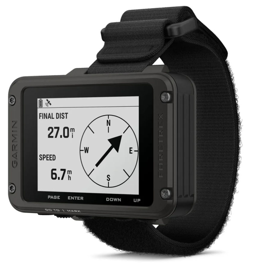
What we like: Great battery life and hands-free convenience.
What we don’t: Can’t download maps onto the device.
Garmin’s wrist-mounted Foretrex 801 offers a unique spin on the standard GPS device, with hands-free operation that makes it popular for hunting, target shooting, and other tactical applications. Like Garmin’s premium offerings, the Foretrex 801 features fast acquisition and accurate recording with GPS, GLONASS, and Galileo support, along with multi-frequency positioning, a 3-axis compass, and a barometric altimeter. Battery life is decent at 100 hours in navigation mode (and an impressive 1,000 hours in expedition mode), and the 801 is as tough as ever with military-grade construction. Taken together, the Foretrex is all of the bones of a handheld unit but none of the bulk, and a highly functional tool for the right user.
Where does the Foretrex 801 fall short? The biggest compromise compared with other options is that you can’t add detailed topographic maps. Instead, you have to use the old-fashioned breadcrumb trail and 3-axis compass for navigation. Further, the 2.2-inch screen is small compared to a standard handheld unit, but on the plus side, it’s easy to read even in direct sunlight. All told, the Foretrex isn’t for everyone, but its simple design, durable build, and fantastic battery life have appeal for backcountry explorers.
See the Garmin Foretrex 801

Weight: 1.9 oz.
Screen: 2 in.
Battery life: 35 hours
What we like: Ultralight; tiny size; covers the basics.
What we don’t: Iffy stock; horrible app UX, sub-par battery life; limited functionality.
If you’re looking for a simple, affordable backup to smartphone navigation, the Bushnell BackTrack Mini GPS stands out as a compelling non-Garmin option. Weighing a scant 1.9 ounces (2.3 oz. with the included tether and carabiner) and hovering just north of $100, the tiny pocket-sized unit is designed for straightforward wayfinding rather than full-on mapping, allowing you to drop waypoints and follow a breadcrumb-style track back to where you started. Despite its minimalist approach, the BackTrack Mini packs in a lot of useful data, including elevation, barometric pressure, coordinates, a reliable digital compass, and sunrise/sunset and hunting and fishing “best times” information. Battery life is poor but understandable given the price, rated up to 24 to 35 hours depending on use. In testing, we've found this to be accurate. The IPX7 waterproof rating and rugged build make it a trustworthy companion for hiking, backpacking, and hunting. Pairing with Bushnell’s smartphone app ("Bushnell Connect")—if you can handle the bugs—expands functionality a bit further, letting you save trips and review mileage and time after the fact, but the device remains fully functional on its own when cell service or phone battery runs out.
That said, the BackTrack Mini’s simplicity and price come with a slew of trade-offs. There are no built-in maps, and the 2-inch screen—while easy to read in direct sunlight—can suffer from glare and can black out at certain angles when wearing polarized sunglasses. We also found the buttons stiff and finicky to press, especially compared to Garmin's more refined handheld GPS units. This is about as bare-bones as we'd go for even a backup GPS unit, but it does deliver the basics in one of the lightest packages we've tested. The app, however, can be downright frustrating. It's tricky to navigate, riddled with bugs, and just feels clunky overall (to the point that we barely use it). Just take a gander at the app store ratings to back us up. As a standalone device, it's fine, but the lack of app functionality limits use. Also, while a max of 35 hours of battery could be fine for short trips, it is limiting on longer excursions, and pales in comparison to the Garmin. Finally, stock can be hit-or-miss across most vendors. In the end, for those who want a lightweight, affordable, and easy-to-use GPS as a safety net rather than a primary navigation tool, the Bushnell BackTrack Mini delivers excellent value and adequate performance at a fraction of the cost of more feature-rich devices. Chuck it in your pack and forget about it until the time comes—this is a nifty little backcountry backup.
See the Bushnell BackTrack Mini GPS
| GPS Device | Price | Weight | Screen | Battery | Memory | Messaging & SOS |
|---|---|---|---|---|---|---|
| Garmin GPSMAP 67i | $600 | 8.1 oz. | 3.0 in. | 180 hrs | 16 GB (accepts microSD) | Yes |
| Garmin eTrex SE | $150 | 5.5 oz. | 2.2 in. | 168 hrs | 28 MB | No |
| inReach Mini 3 Plus | $500 | 4.4 oz. | 1.9 in. | 350 hrs | Unavailable | Yes |
| Garmin Montana 710i | $800 | 14.5 oz. | 5.0 in. | 24 hrs | 32 GB (accepts microSD) | Yes |
| Garmin Foretrex 801 | $250 | 3.8 oz. | 2.2 in | 100 hrs | Unavailable | No |
| Bushnell BackTrack Mini | $75 | 1.9 oz. | 2.0 in. | 35 hrs | Unavailable | No |
From local backwood romps to international expeditions in far-flung mountain ranges, the Switchback Travel team spends a significant amount of time each year in the backcountry. In doing so, they frequently find themselves outside cell service range and have consequently sampled just about every reliable GPS in search of the best handheld models available. Our initial selection of nine models was wrangled together back in 2016. We've had our finger on the pulse of the GPS market ever since and update this round-up multiple times each year, adding standout models to the list as they surface.
Senior editor Chris Carter inherited this guide in early 2024. An ardent long-distance thru-hiker and bona fide backcountry bushwhacker, Chris has spent endless months wandering through remote areas devoid of service. He's put handheld GPS devices through torture and torment, allowing only the best in this guide. After all, these little bricks could be the difference between life and death in the backcountry. In testing, we keep a keen eye for several key metrics, including mapping capabilities, battery life, navigation interface, and weight. Each device is rigorously tested on real-world adventures before landing a spot on our list. It's also worth mentioning that this guide focuses specifically on handheld GPS devices. For lists covering similar categories, be sure to check out our articles on the best satellite messengers, best GPS watches, and best fitness watches.
.jpg)
As with smartphones, touchscreens are becoming more prevalent in the handheld GPS market. These devices are intuitive, easy to navigate or type with, and work in both landscape and portrait orientations. But a few reasons some of the best-rated models are laden with buttons, including Garmin's GPSMAP 67i, are that the touchscreen tech and built-in software aren't as advanced as our expensive phones, nor as consistent in rough and cold weather. Further, using a touchscreen can be a pain with gloves, despite technologies that make some gloves work decently well.

But for all those complaints, there is an equally good argument that a touchscreen is the better choice over buttons. Buttons add bulk, and if you need to type, they are cumbersome and slow to navigate an on-screen keyboard. Your preferred style will vary, but if you’re wearing gloves most of the time, need to quickly navigate between screens while on the move, or operate the GPS in frigid temperatures, buttons are best. As touchscreen technology continues to improve, including the current option to adjust the screen's sensitivity, its sleek, low-profile design, which allows more space for the screen, will continue to win over more and more users.
.jpg)
One of the main reasons to upgrade to a high-end GPS is its large screen. For boating, hunting, and motorized activities, a larger screen is helpful for seeing information at a glance. Hikers, backpackers, and long-distance adventurers such as thru-hikers or bikepackers will still be happiest with a small, light device, such as the eTrex SE (2.2 in. diagonally) or the inReach Mini 3 Plus (1.9 in. diagonally). For geocaching, a small or midsize screen should do the trick. The larger GPSMAP 64 and 65 (2.6 in.) and 67 (3 in.) have long been popular with mountain bikers and geocachers.

Screen brightness and readability in direct sunlight are important considerations. Thankfully, this has been an area of emphasis for Garmin lately, and their new models excel with anti-glare screens with good backlighting and contrast that make maps and text easy to decipher. One of the best models is the Garmin Montana, while the monochrome eTrex falls short. In the end, readability is a strength among handheld devices.
In researching GPS devices, you’re bound to run across the term GNSS, which is short for Global Navigation Satellite Systems. GNSS encompasses the entire “constellation” of satellite systems, including GPS (U.S.), GLONASS (Russia), Galileo (EU), QZSS (Japan), BeiDou (China), and IRNSS (India). Thus, when manufacturers say a device offers “multi-GNSS support,” this means that the device connects to more than one satellite system. For example, Garmin’s Montana 710i connects to GPS, GLONASS, and Galileo, while its GPSMAP 67i offers those three plus QZSS, BeiDou, and IRNSS support. In 2025, almost all designs feature multi-GNSS support, including even the inReach Mini 3 Plus.

The big takeaway for most users is accuracy: If a device can connect to multiple satellite systems, it’s more likely to be able to get a quick and precise location fix, no matter your position in the world. Do keep in mind that connecting to multiple satellite systems will drain your battery faster than connecting to just GPS; the good news is that most devices let you customize your connection for the best balance of accuracy and battery efficiency.
It’s also worth mentioning multi-band GNSS (also known as dual-frequency GPS), which has become a staple of GPS technology over the past few years. Handheld devices with multi-band GNSS not only connect to multiple networks but also use two different frequencies to connect to each network. The result is a quicker connection and even greater position accuracy, especially in areas lacking a clear view of the sky (think: tall buildings, canyons, or trees). Garmin has a helpful video explaining multi-band GNSS.
.jpg)
All handheld devices come with some form of base map—essentially a blank screen that includes major local features or a preloaded track—while many include detailed maps or the option to upload more later. Most modern models (like the GPSMAP 67i and Montana 710i) offer TopoActive mapping, an extensive program with contour lines to indicate elevation gained/lost, points of interest, and some on- and off-road navigation based on your country of origin (i.e., a device purchased in the U.S. will have a North American TopoActive map). Notably, the 67i and 700i also offer an Outdoor Maps+ subscription for additional information like up-to-date public land boundaries, landowner names, wildlife areas, and more.
.jpg)
One of the biggest indicators of a device’s mapping power is its capacity for internal and external (i.e., microSD) memory storage—a spec that we include in our comparison table above. The more storage you have, the more detailed (and extensive) the maps can be. For example, the GPSMAP 67i has 16 GB of internal storage and can accommodate a 32 GB microSD card (for a total of 48 GB). On the other hand, the eTrex SE has just 28 megabytes of storage (and does not accommodate a microSD card). While the eTrex SE only offers rudimentary breadcrumb navigation, it does pair with the Garmin Explore app (on a smartphone) to offer more detailed maps.
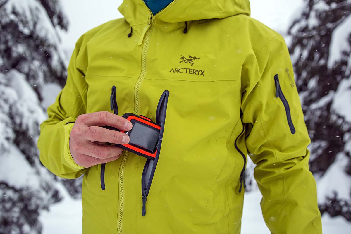
A growing number of GPS devices can now transmit messages or SOS alerts via satellite. Paired with a subscription (often billed monthly with a one-time setup fee), this tech lets you connect in areas without cell service, including sending and receiving texts, posting to social media, sharing your location, and communicating between GPS devices. The benefits are endless, and vital in the event of an accident. We’ve used our GPS device to get weather reports in the North Cascades, schedule flights in the Alaska Range, and even send messages for supply drops in the African bush. Communication can be managed on the device’s screen, but on smaller devices (like the Garmin inReach Mini 3 Plus), the ability to pair with your smartphone via Bluetooth is a welcome feature. A number of models come with satellite connectivity, including the Garmin inReach Mini 3 Plus, GPSMAP 67i, and Montana 710i. For a deeper dive into the topic, see our article on the best satellite messengers.

The longtime standard for batteries in GPS devices has been the trusty AA. They are cheap, have decent lifespans, and can be swapped out when they are drained. That said, if you are heading out for an extended trip, you'll need to bring several backup batteries. Extra stuff brings extra weight and inconvenience, and then there’s the hassle of disposing of used batteries correctly. So while AA batteries remain an option for many GPS devices, Garmin and others have turned to rechargeable battery packs as a compelling alternative.
.jpg)
The main advantage of rechargeable batteries is the ability to reduce the weight and bulk of your pack—and over time, the cost savings can add up. And with portable solar panels and power banks becoming increasingly reliable (the Anker PowerCore is our current favorite), there are few downsides. As a result, rechargeable battery packs now come preinstalled on many of Garmin’s most premium models (such as the GPSMAP 67i and Montana 710i), and many devices that take AAs are also compatible with a rechargeable lithium-ion pack (sold separately).
Nearly all handheld GPS devices list a barometric altimeter and a three-axis compass. The advantage of the electronic compass is its ability to read direction no matter how you’re holding the device, whether you’re moving or still. Standard compasses must be held horizontally to orient properly (or be moving if it's GPS-based). It’s a small but nice addition, particularly if you need to hold the device upright to get a signal. Getting a read on barometric pressure helps determine elevation because the higher you go, the lower the pressure. The science isn’t perfect, however, because when the weather shifts, barometric pressure also changes, which can skew the numbers. That said, a barometric altimeter remains the best option for mountainous and backcountry use and can provide a helpful approximation of your current elevation.

In most cases, dimensions and weight correspond with screen size. Some of the smallest and lightest handheld options on our list, like the Garmin Foretrex 801 and Garmin inReach Mini 3 Plus, have very small screens (2.2 in. and 1.9 in., respectively). How you’ll use the device will determine how important dimensions and weight are. Those who opt for high-end, heavier devices like the Montana 710i are not typically carrying them in their hand or hiking with a pack; instead, they place them on a handlebar mount for overlanding, ATVing, or snowmobiling (Garmin sells convenient handlebar mounts for motorcycles or bikes for its Montana 710 and 710i).

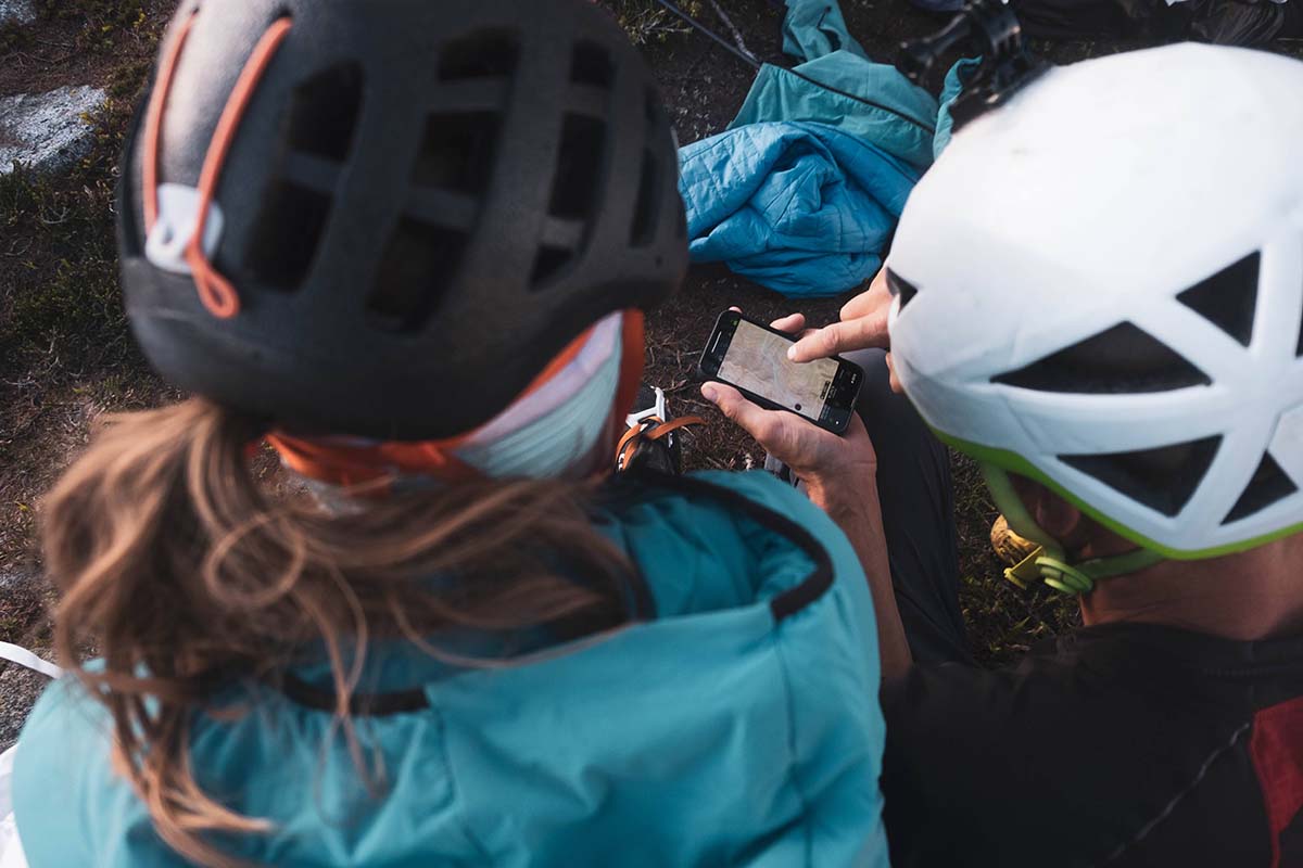
Smartphones have been eroding the handheld GPS market for years. And the reasons are obvious: Most hikers and backcountry explorers already have their phones along to capture photos or reference route information, and the simplicity of keeping everything on one device is a big plus. In addition, prior concerns with durability have been partially addressed with burlier carrying cases and increased water and drop protection. However, in terms of mapping and accuracy, handheld devices still have the upper hand with greater compatibility with a wider array of satellite systems (smartphones use cell towers and GPS but not other GNSS networks), which can be valuable in deep backcountry areas with challenging coverage.
.jpg)
That said, most hikers, backpackers, and climbers will be happy with the performance of a smartphone, and there are a number of quality mapping apps available for free or a small charge. Popular choices include Gaia, CalTopo, onX Backcountry (all subscription-based services), and Topo Maps+, which allow you to download quality USGS topos. Our author has used Gaia's international capabilities to navigate off the beaten path in remote areas of Africa, Europe, Nepal, and across the United States, with very few accuracy issues (other apps, such as onX Backcountry, don't boast the same international capabilities). Additionally, now that the current iPhones have an impressive satellite SOS function, smartphones are an even more attractive alternative to handheld GPS devices.

The main hang-up with going the smartphone route is battery life. It’s true you can charge while on-the-go via a solar panel or portable charger, but GPS-based apps are battery hogs and can’t come close to the ease of use and longevity of a handheld GPS. As things currently stand, this is the main reason to opt for a handheld over a smartphone. And poor battery life aside, it’s always a good idea to have a backup GPS device on hand in the backcountry, even if you plan to use your smartphone as your primary navigator or SOS beacon. Smartphones—as mentioned earlier—aren't as accurate, have shorter battery life, and are used for many other functions (e.g., taking photos and field notes) besides navigation on an adventure.
.jpg)
In addition to smartphone GPS apps, GPS-equipped watches are another relatively new piece of technology giving handheld GPS devices a run for their money. Like a standard GPS device, these watches let you find your location on preloaded maps, upload and follow .gpx tracks, record your route, retrace your steps, and even pan out to view your surroundings. With the most basic navigation, you’ll see a simple line with a waypoint marker on an otherwise blank screen, while the most premium watches (the Garmin Fenix 8, for example) feature preloaded color topographic maps with detailed contour lines, geographic place names, and more. At best, you get most of the features of a handheld GPS device packed into a streamlined wrist watch.
.jpg)
But while the technology is impressive, we have a hard time recommending a GPS watch as a full-blown substitute for a GPS device. The small screen and controls are painstaking to navigate unless you put in the time to learn the system, and the mapping functions can drain a watch’s battery life. And in most cases, you’ll pay more for the smaller device. For example, the Garmin Fenix 8 watch will cost you over $1,000, while the premium Garmin GPSMAP 67i handheld is hundreds less (including satellite messaging and SOS). But for those who value the streamlined package and only use GPS occasionally, a high-end GPS watch is an intriguing option.
Back to Our Top Handheld GPS Picks Back to Our Handheld GPS Comparison Table

.jpg?h=fbc67360&itok=MccIKDDP)
.jpg?h=fbc67360&itok=cDloWMjr)

_0.jpg?h=fbc67360&itok=J5FNnfpJ)
.jpg?h=fbc67360&itok=dkRs76Ki)


